The Mythenregion is located in the heart of Central Switzerland and can be easily reached from Zug, Lucerne, Zurich or the canton of Aargau in 30-60 minutes. The ski area offers 50 kilometres of pistes, a unique freestyle park, the Kabi children's park and various magic carpets for the youngest guests. The variety of leisure activities in the family ski area is great. Cool toboggan runs, varied snowshoe trails, winter hiking trails and a cross-country ski trail - there is bound to be something for everyone. And for your well-being, the hosts of our cosy restaurants and piste bars look forward to your visit.
A warm welcome to the Mythenregion.
The Mythenregion is located in the heart of Central Switzerland and can be easily reached from Zug, Lucerne, Zurich or the canton of Aargau in 30-60 minutes. The ski area offers 50 kilometres of pistes, a unique freestyle park, the Kabi children's park and various magic carpets for the youngest guests. The variety of leisure activities in the family ski area is great. Cool toboggan runs, varied snowshoe trails, winter hiking trails and a cross-country ski trail - there is bound to be something for everyone. And for your well-being, the hosts of our cosy restaurants and piste bars look forward to your visit. A warm welcome to the Mythenregion.
The freestyle park "Mythenpark" in the heart of Central Switzerland is located between Grossenboden and Brünnelistock in a varied terrain. This is suitable for professionals but also for beginners.
Sledging fun on 10 km of great and varied sledging trails. The longest toboggan run is 4.5 km and starts at Rotenflue and goes all the way to Rätigs. Fun for young and old.
Winter hiking/Snowshoeing
Details
Winter walking paths open
0.0/39.0 km
Snowshoe trails open
0.0/44.6 km
Winterwanderwege Mythenregion
Key Value List
Winter walking paths from (altitude)
1500 m (altitude)
Number of snow shoe trails open today
0
Conditions/events on the trails
End of season
Snowshoe walking
Schneeschuhtrails Mythenregion (Schweiz Mobil Nr. 818/819)
(0.0 km)
Type: Snowshoeing
Conditions: Closed
0.0/35.0 km open
Rundweg St. Karl - Oberberg - St. Karl
(0.0 km)
Type: Snowshoeing
Conditions: End of season
0.0/2.5 km open
Schneeschuhtrail Illgau, St. Karl - Ober Altberg - Illgau, St. Karl (Schweiz Mobil Nr. 819)
(0.0 km)
Type: Snowshoeing
Conditions: End of season
0.0/7.1 km open
Winter hiking/Snowshoeing
Handgruobi - Grossenboden
(0.0 km)
Type: Hiking trail
Conditions: No notification
0.0/2.0 km open
Ibergeregg - Grossenboden
(0.0 km)
Type: Hiking trail
Conditions: No notification
0.0/0.8 km open
Ibergeregg - Zwäcken - Grossenboden - Ibergeregg (Schweiz Mobil Nr. 564)
(0.0 km)
Type: Hiking trail
Conditions: No notification
0.0/5.0 km open
Ibergeregg - Zwäcken - Rotenflue - Holzegg
(0.0 km)
Type: Hiking trail
Conditions: No notification
0.0/9.7 km open
Rotenflue Rundweg (Schweiz Mobil Nr. 562)
(0.0 km)
Type: Hiking trail
Conditions: End of season
0.0/2.0 km open
Bogenfang - Brunni
(0.0 km)
Type: Hiking trail
Conditions: Closed
0.0/4.0 km open
Schlittelstübli - Brunni
(0.0 km)
Type: Hiking trail
Conditions: Closed
0.0/2.0 km open
Ibergeregg-Talstation Lauchern/Oberiberg (Schweiz Mobil Nr. 565)
(0.0 km)
Type: Hiking trail
Conditions: Closed
0.0/5.0 km open
Chäferliweg
(0.0 km)
Type: Hiking trail
Conditions: End of season
0.0/0.0 km open
Rundweg Ibergeregg - Oberberg - St. Karl (Schweiz Mobil Nr. 561)
(0.0 km)
Type: Hiking trail
Conditions: Closed
0.0/6.0 km open
St. Karl - Oberberg - Ober Zimmerstalden - St. Karl
(0.0 km)
Type: Hiking trail
Conditions: Closed
0.0/2.5 km open
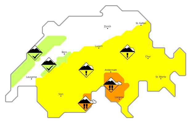
40 km of winter hiking and 45 km of snowshoe trails stretch across the entire Mythen region. Breathe in the fresh air and hike silently through the snow-covered forests, a magnificent panorama with a view of Lake Lucerne.
Dogs are very welcome in the Mythenregion. However, we kindly ask you to keep your dog on a leash to protect the wildlife in the banned area. Dogs are allowed on the Rotenfluebahn and in the restaurant Gipfelstubli. The cost of a ride on the gondola is CHF 5.00 for a medium and large dog (>30 cm).
Dogs are very welcome in the Mythenregion. However, we kindly ask you to keep your dog on a leash to protect the wildlife in the banned area. Dogs are allowed on the Rotenfluebahn and in the restaurant Gipfelstubli. The cost of a ride on the gondola is CHF 5.00 for a medium and large dog (>30 cm).
All information is the responsibility of local partners; weather data supplied by SRF Meteo.
 01
01