Highest in the Simmental, at the foot of the Wilstrubel massif, lies the beautiful town of Lenk at 1'068 m. In the summertime, incredible hikes to mountain passes, uplifting tours in the high alpine regions, alpine meadows in full bloom, crashing waterfalls, and crystal-clear mountain lakes are all on offer. Lenk is a paradise for families and nature lovers alike.
Weather forecast
Winter sports report
Snow report
n/a
Depth of snow
n/a
Snow condition
no info
Last snowfall
07.04.2023
Lenk i.S.
Key Value List
Depth of snow in resort at 1068 metres
–
Depth of snow on upper runs at 1946 metres
–
Last snowfall in resort
01.03.2023
Last snowfall in ski area
07.04.2023
New snow in resort (past 24h)
0 cm
New snow in ski area (past 24h)
0 cm
Comments from the station crew:
Lifts:
Detailed operating hours on the Internet: www.lenk-bergbahnen.ch
Comments from the station crew:
Detailed operating hours on the Internet: www.lenk-bergbahnen.ch
Piste
0.0/121.7 km open
Pistes open (open today/total)
0.0/121.7 km
Slope condition
no info
0/10 Runs down to resort (open/total)
Adelboden-Lenk
Key Value List
Runs down to resort (open today / total)
0/10
Runs down to (altitude)
–
Condition of runs down to resort
closed
Surface area of pistes
0.00 km²
Number of local pistes
67
Pistes covered by lift pass (regional)
210 km
Number of lifts in ski area
69
Runs floodlit today until
–
Length of floodlit runs
0.0 km
Augstchummi
(0.0 km)
Type: Yellow track (not prepared)
Conditions: closed
0.0/0.5 km open
Badweide
(0.0 km)
Type: Black track
Conditions: closed
0.0/0.9 km open
Balmen
(0.0 km)
Type: Blue track
Conditions: closed
0.0/0.9 km open
Bergläger - Rehärti
(0.0 km)
Type: Blue track
Conditions: closed
0.0/2.3 km open
Brenggen
(0.0 km)
Type: Blue track
Conditions: closed
0.0/1.1 km open
Brenggen - Bühlbergpiste
(0.0 km)
Type: Blue track
Conditions: closed
0.0/1.3 km open
Brenggen - Hahnenmoosläger
(0.0 km)
Type: Blue track
Conditions: closed
0.0/0.3 km open
Brenggen-Piste GMP Beginner
(0.0 km)
Type: Orange track (ski route/fun-slope)
Conditions: closed
0.0/0.4 km open
Bühlberg - Metschmaad
(0.0 km)
Type: Blue track
Conditions: closed
0.0/2.5 km open
Bühlberg Nord
(0.0 km)
Type: Blue track
Conditions: closed
0.0/2.3 km open
Bühlberg Süd
(0.0 km)
Type: Blue track
Conditions: closed
0.0/2.2 km open
Chatzenhubel - Bergläger
(0.0 km)
Type: Blue track
Conditions: closed
0.0/3.0 km open
Chuenis - Bergläger
(0.0 km)
Type: Blue track
Conditions: closed
0.0/1.9 km open
Chuenis-Bergläger
(0.0 km)
Type: Red track
Conditions: closed
0.0/1.4 km open
Chuenis-Bode
(0.0 km)
Type: Blue track
Conditions: closed
0.0/2.1 km open
Chuenis-Chäle
(0.0 km)
Type: Red track
Conditions: closed
0.0/1.8 km open
Chummi
(0.0 km)
Type: Red track
Conditions: closed
0.0/2.3 km open
Chummi - Geils
(0.0 km)
Type: Red track
Conditions: closed
0.0/2.1 km open
FIS
(0.0 km)
Type: Red track
Conditions: closed
0.0/2.0 km open
Geils - Bergläger
(0.0 km)
Type: Blue track
Conditions: closed
0.0/2.5 km open
Guetfläck
(0.0 km)
Type: Blue track
Conditions: closed
0.0/1.6 km open
Guetfläck - Chummi
(0.0 km)
Type: Red track
Conditions: closed
0.0/0.6 km open
Guetfläck - Metschberg
(0.0 km)
Type: Blue track
Conditions: closed
0.0/1.2 km open
Hahnenmoos - Geils
(0.0 km)
Type: Blue track
Conditions: closed
0.0/1.6 km open
Hasler
(0.0 km)
Type: Blue track
Conditions: closed
0.0/3.0 km open
Hasler - Wallegg
(0.0 km)
Type: Blue track
Conditions: closed
0.0/2.6 km open
Hasler Rennstrecke
(0.0 km)
Type: Blue track
Conditions: closed
0.0/0.9 km open
Holzegg
(0.0 km)
Type: Black track
Conditions: closed
0.0/1.6 km open
Höchst-Chuenis
(0.0 km)
Type: Red track
Conditions: closed
0.0/0.3 km open
Juskila
(0.0 km)
Type: Red track
Conditions: closed
0.0/1.4 km open
Kehrweide
(0.0 km)
Type: Red track
Conditions: closed
0.0/2.8 km open
Klusi
(0.0 km)
Type: Black track
Conditions: closed
0.0/2.0 km open
Lavey - Hahnenmoos
(0.0 km)
Type: Red track
Conditions: closed
0.0/1.0 km open
Lavey - Stand
(0.0 km)
Type: Red track
Conditions: closed
0.0/1.0 km open
Laveygrat-Bühlberg
(0.0 km)
Type: Blue track
Conditions: closed
0.0/0.5 km open
Leiterli - Stoss
(0.0 km)
Type: Blue track
Conditions: closed
0.0/6.5 km open
Lägerpiste
(0.0 km)
Type: Black track
Conditions: closed
0.0/0.6 km open
Mauren
(0.0 km)
Type: Blue track
Conditions: closed
0.0/2.0 km open
Metsch - Bühlberg
(0.0 km)
Type: Blue track
Conditions: closed
0.0/2.4 km open
Metschberg - Guetfläck
(0.0 km)
Type: Blue track
Conditions: closed
0.0/1.0 km open
Metschmaad - Metsch
(0.0 km)
Type: Blue track
Conditions: closed
0.0/0.7 km open
Metschstand - Bergstation Brenggen
(0.0 km)
Type: Red track
Conditions: closed
0.0/1.7 km open
Mulkerblatten - Wallegg
(0.0 km)
Type: Red track
Conditions: closed
0.0/2.5 km open
Murbipiste
(0.0 km)
Type: Red track
Conditions: closed
0.0/0.6 km open
Mülkerblatten - Hasler
(0.0 km)
Type: Blue track
Conditions: closed
0.0/3.4 km open
Rehbockpiste
(0.0 km)
Type: Red track
Conditions: closed
0.0/0.8 km open
Rosshubel - Aebi
(0.0 km)
Type: Red track
Conditions: closed
0.0/1.8 km open
Rosshubel - sandige Boden
(0.0 km)
Type: Red track
Conditions: closed
0.0/0.8 km open
Schattwy
(0.0 km)
Type: Blue track
Conditions: closed
0.0/1.4 km open
Seelipiste
(0.0 km)
Type: Red track
Conditions: closed
0.0/2.1 km open
Sillerenbühl - Rosshubel
(0.0 km)
Type: Red track
Conditions: closed
0.0/1.0 km open
Sillerenbühl - Aebi
(0.0 km)
Type: Red track
Conditions: closed
0.0/1.9 km open
Sillerenbühl - Bergläger
(0.0 km)
Type: Blue track
Conditions: closed
0.0/5.0 km open
Sillerenbühl - Geils
(0.0 km)
Type: Blue track
Conditions: closed
0.0/2.3 km open
Sonnenhang
(0.0 km)
Type: Blue track
Conditions: closed
0.0/2.7 km open
Sonnenmeder
(0.0 km)
Type: Red track
Conditions: closed
0.0/0.5 km open
Stand - Hahnenmoosgraben
(0.0 km)
Type: Red track
Conditions: closed
0.0/1.4 km open
Stand - Rosshubel
(0.0 km)
Type: Red track
Conditions: closed
0.0/0.6 km open
Stand - sandige Boden
(0.0 km)
Type: Red track
Conditions: closed
0.0/0.9 km open
Stoss - Lenk
(0.0 km)
Type: Blue track
Conditions: closed
0.0/3.0 km open
Talpiste Aebi - Oey
(0.0 km)
Type: Blue track
Conditions: closed
0.0/3.1 km open
Tanzboden
(0.0 km)
Type: Red track
Conditions: closed
0.0/0.7 km open
Tschuggen
(0.0 km)
Type: Red track
Conditions: closed
0.0/6.9 km open
Täli
(0.0 km)
Type: Red track
Conditions: closed
0.0/0.3 km open
Wallegg - Lenk
(0.0 km)
Type: Red track
Conditions: closed
0.0/4.8 km open
Weltcup
(0.0 km)
Type: Black track
Conditions: closed
0.0/1.6 km open
Zubringer Gondelbahn
(0.0 km)
Type: Blue track
Conditions: closed
0.0/0.9 km open
Comments from the station crew:
Piste:
Outside the operating hours of the lifts, the ski runs are closed and are not protected against any dangers such as avalanche blasting or piste machines with cable winches. Danger to life!
Comments from the station crew:
Cross-country skiing:
Cross-country trails may also be open in sections, depending on snow conditions. Detailed information is available from the Tourist Center Lenk on +41 33 736 35 35.
Snow Park
0/4
Snowcross pistes open
0/1
Snow park open
0/2
AirBoard pistes open
0/1
Gran Masta Park Adelboden-Lenk
Key Value List
Snow Park condition
end of season
Snow park floodlighting
–
Snowboard facilities floodlit today until
-
Tel. for fun park info
+41 33 952 52 52
AUDI Skicross Gold Park Betelberg
Status: closed
Gran Masta Park Brenggen
Status: closed
Leiterli - Stoss (Airboard)
Status: closed
SnowPark Crazy
Status: closed
Comments from the station crew:
Snow Park:
Individual fun facilities may be temporarily closed to the public due to events and reservations.
Tobogganing:
Information shuttle service: Please note the bus timetable and the rates for the shuttle service between Pöschenried and the Betelberg valley station at lenk-bergbahnen.ch/schlitteln
Winter hiking
Details
Winter walking paths open
47.5/63.5 km
Snowshoe trails open
18.9/23.2 km
Lenk
Key Value List
Winter walking paths from (altitude)
1068 m (altitude)
Number of snow shoe trails open today
4
Conditions/events on the trails
End of season
Bühlberg - Metsch
(0.0 km)
Type: Snowshoeing
Conditions: Closed
0.0/1.6 km open
Leiterli - Haslerbar
(0.0 km)
Type: Hiking trail
Conditions: Closed
0.0/2.0 km open
Leiterli - Stoss
(0.0 km)
Type: Hiking trail
Conditions: Closed
0.0/3.0 km open
Lenk - Iffigfall (Fahrstrasse)
(6.0 km)
Type: Hiking trail
Conditions: Good
6.0/6.0 km open
Lenk - Reka Zentrum - Aegerten Stein - Lenk
(13.0 km)
Type: Hiking trail
Conditions: Good
13.0/13.0 km open
Lenk - Simmenfälle
(6.0 km)
Type: Hiking trail
Conditions: Good
6.0/6.0 km open
Lenk - Wallegg (Fahrstrasse)
(5.0 km)
Type: Hiking trail
Conditions: Good
5.0/5.0 km open
Metsch - Lenk (Fahrstrasse)
(4.5 km)
Type: Hiking trail
Conditions: Good
4.5/4.5 km open
Metsch - Metschmaad - Bühlberg
(0.0 km)
Type: Snowshoeing
Conditions: Closed
0.0/2.7 km open
Oey - Iffigfall
(4.0 km)
Type: Snowshoeing
Conditions: Good
4.0/4.0 km open
Rundweg Bühlberg
(4.0 km)
Type: Snowshoeing
Conditions: Good
4.0/4.0 km open
Rundweg Hubelmatte - Pörisgrat
(5.6 km)
Type: Snowshoeing
Conditions: Good
5.6/5.6 km open
Rundweg Leiterli - Loipe - Leiterli
(0.0 km)
Type: Hiking trail
Conditions: Closed
0.0/2.8 km open
Rundweg Leiterli - Steinstoss - Agematte - Leiterli
(0.0 km)
Type: Hiking trail
Conditions: Closed
0.0/3.2 km open
Rundweg Leiterli - Tschätte - Leiterli
(0.0 km)
Type: Hiking trail
Conditions: Closed
0.0/5.0 km open
Rundweg Lenk - Lenkersee - Oey - KUSPO
(5.0 km)
Type: Hiking trail
Conditions: Good
5.0/5.0 km open
Rundweg Lenk - Schadauli - Reka - Lenk
(6.0 km)
Type: Hiking trail
Conditions: Good
6.0/6.0 km open
Rundweg Lenk - Seefluh - Blatti
(5.3 km)
Type: Snowshoeing
Conditions: Good
5.3/5.3 km open
Rundweg Lenkersee
(2.0 km)
Type: Hiking trail
Conditions: Good
2.0/2.0 km open
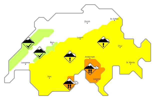
Meteorological conditions in the mountains may change quickly. Please note that natural influences can affect the accessibility and can also lead to changes at short notice. If you are in any doubt, please contact the Tourist Centre Lenk on +41 33 736 35 35.
The ski passes are valid throughout the entire ski region Adelboden-Lenk. Reduced ski passes can be purchased online (for the entire ski region or for Betelberg.) Reduced 1-day tickets are available for Betelberg Lenk. Ski passes can be purchased online in the webshop.
The tariffs of the season tickets are valid as advance sales tariff from 01 November to 15 December 2022. The Top 4 season ticket is valid in the 4 ski regions Adelboden-Lenk, Gstaad, Jungfrau Ski Region and Meiringen-Hasliberg. From the 2021/22 winter season, the Top4 season ticket is no longer valid on the Boltigen-Jaunpass and Kandersteg lifts.
Betelberg family day ticket: The family promotion at Betelberg is suitable for parents and their children up to their 16th birthday. The family day ticket is available on Wednesday and Saturday for CHF 130.
Beginner ticket: The beginner ticket for the Kinderland Stoss is ideal for the first attempts on skis or snowboard. The Beginner Ticket includes the facilities of Kinderland Stoss as well as the return journey on the Betelberg gondola. Children for CHF 19, adults for CHF 37.
The ski passes are valid throughout the entire ski region Adelboden-Lenk. Reduced ski passes can be purchased online (for the entire ski region or for Betelberg.) Reduced 1-day tickets are available for Betelberg Lenk. Ski passes can be purchased online in the webshop.
The tariffs of the season tickets are valid as advance sales tariff from 01 November to 15 December 2022. The Top 4 season ticket is valid in the 4 ski regions Adelboden-Lenk, Gstaad, Jungfrau Ski Region and Meiringen-Hasliberg. From the 2021/22 winter season, the Top4 season ticket is no longer valid on the Boltigen-Jaunpass and Kandersteg lifts.
All information is the responsibility of local partners; weather data supplied by SRF Meteo.